Land Use Planning Guide: Principles, Process, and Best Practices
Land use planning is how governments and planners manage growth, zoning, and resources. Learn the process, levels, and strategies for smarter development.
Land use planning shapes how land is organized, developed, and protected to support thriving communities. It’s where policy meets design, guiding how housing, infrastructure, and natural spaces fit together to create livable, sustainable cities.
This guide outlines the planning process, common land use categories, and how smart, coordinated planning creates cities that grow sustainably and function beautifully.
TL;DR
Land use planning connects policy, process, and design to guide sustainable growth. It follows clear steps from data collection to implementation, ensuring coordinated decisions across sectors. Through collaboration and regulation, it strengthens infrastructure delivery and reduces land conflicts. The result is resilient communities where housing, economy, and nature thrive together.
What is Land Use Planning?
Land use planning is the process of regulating how land is used to guide development, manage resources efficiently, and support community well-being. It involves analyzing current conditions, identifying future needs, and using planning tools such as zoning to allocate land for housing, infrastructure, commerce, agriculture, and conservation.
Through clear policies and data-driven analysis, land use planning directs how areas grow and function. It balances economic development, housing demand, and environmental protection to create sustainable, livable communities.
In simple terms, land use planning defines how land supports shared goals while safeguarding natural systems for future generations. It shapes the built environment, coordinates public investment, and ensures that development aligns with long-term priorities.
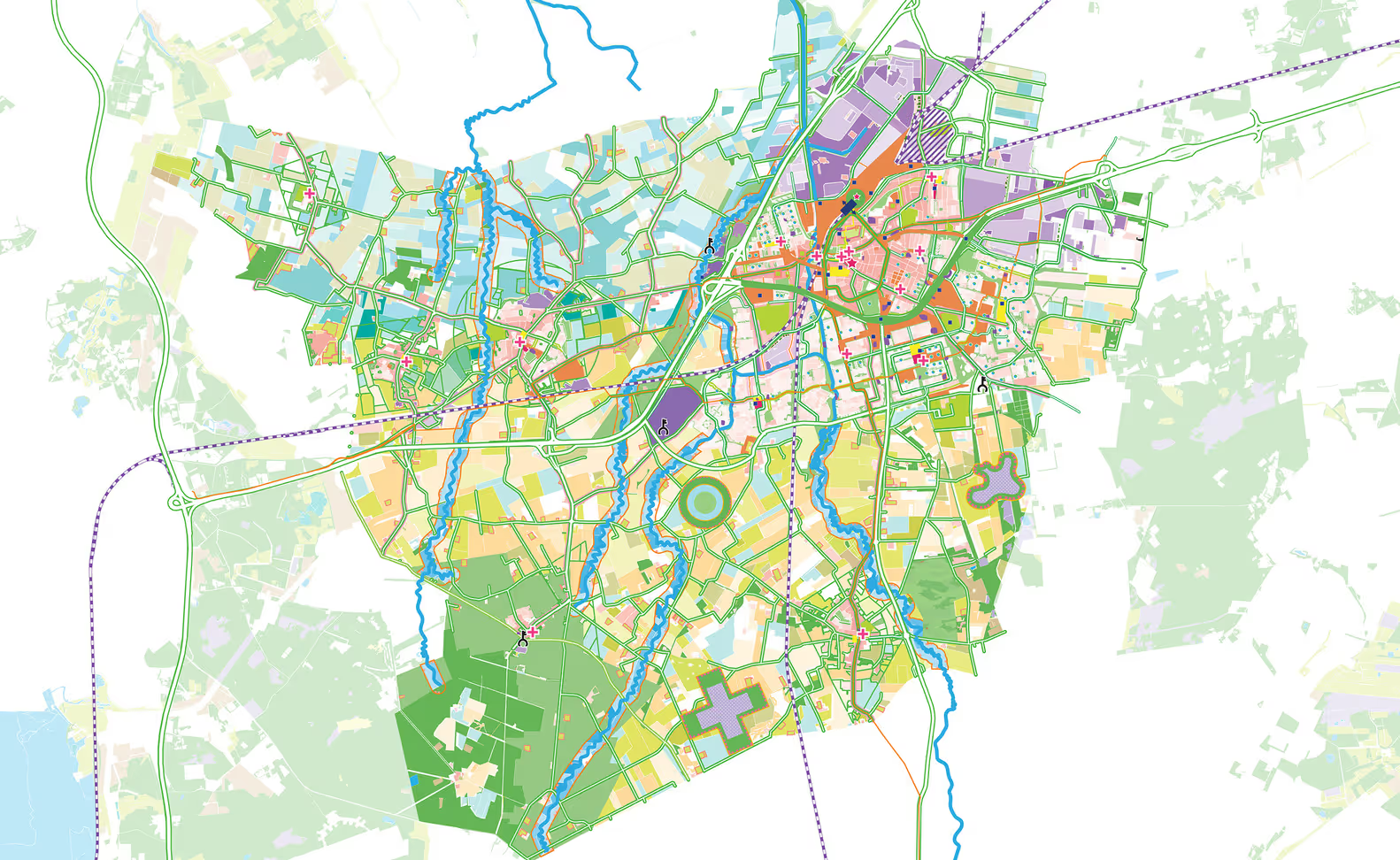
MVRDV’s strategic land use masterplan illustrating zoning, transport, and green networks in Roosendaal. Source: ArchDaily
Why is Land Planning Important?
Land planning keeps growth organized, guiding how cities expand and infrastructure develops over time. It provides a framework for managing change as populations rise and development accelerates worldwide.
Here’s why it’s essential in shaping sustainable and efficient places:
Enables organized growth: Directs where housing, roads, and utilities should go to support livable, connected communities.
Supports infrastructure delivery: Ensures new development aligns with transport networks, utilities, and public services.
Protects natural resources: Safeguards land, water, and ecosystems from overuse and degradation.
Guides investment: Helps developers and governments prioritize projects that deliver long-term social and economic value.
Prevents land conflicts: Clarifies land use policies and reduces disputes between residents, authorities, and private sectors.
As global cities face rapid urbanization and climate challenges, effective land use planning builds resilience and structure into future growth. It links policy goals with on-the-ground delivery, ensuring that infrastructure and development happen efficiently and sustainably.
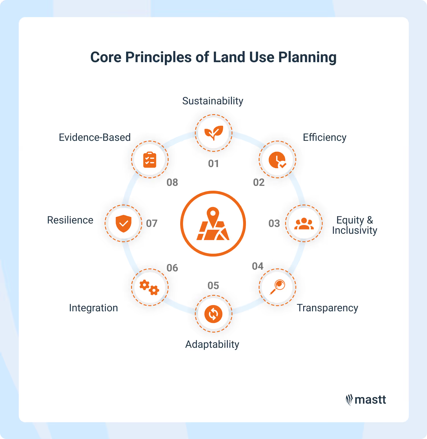
What are the Core Principles of Land Use Planning?
Effective land use planning starts with guiding principles that shape how land is managed and developed responsibly. Many of these principles reflect global frameworks such as UN-Habitat and Sustainable Development Goal 11, which promote inclusive and resilient communities.
Below are the key foundations of effective land use planning practiced globally:
Sustainability: Protects land and natural resources while promoting balanced economic and social growth.
Efficiency: Encourages compact, connected development that makes the best use of existing infrastructure and services.
Equity and Inclusivity: Ensures access to housing, transport, and public spaces for all residents and communities.
Transparency: Builds trust through open information, consistent policies, and participatory decision-making.
Adaptability: Responds to shifts in population, climate, and technology with flexible planning frameworks.
Integration: Coordinates housing, transport, and infrastructure planning to achieve cohesive urban design and development outcomes.
Resilience: Prepares cities and regions to withstand environmental risks and recover from natural or economic disruptions.
Evidence-Based Planning: Uses spatial data, analysis, and community feedback to support informed, accountable land use decisions.
Together, these principles create a consistent framework that keeps land use planning relevant and responsive to modern challenges. They guide how planners align community goals with development pressures, ensuring each project contributes to sustainable, well-connected, and livable places.
Core principles help land use planners create smarter, more resilient, and balanced land development.
Common Land Use Categories and How They Influence Planning
Before the planning process begins, understanding the types of land involved is essential. Each category serves a different purpose and carries its own development potential, constraints, and policy considerations.
Here’s a table outlining the main land categories commonly considered in land use planning and development:
Type of Land
Description
Planning Considerations
Residential
Used for housing and related community services. Can range from low-density suburbs to high-rise urban districts.
Density limits, access to transport and utilities, and balance with nearby uses.
Commercial
Allocated for offices, retail, hospitality, and mixed-use centers. Often located near transport corridors and population hubs.
Traffic impact, parking demand, and compatibility with surrounding areas.
Industrial
Dedicated to manufacturing, logistics, and warehousing. Usually positioned on city edges or near major roads and ports.
Buffer zones, environmental controls, and efficient infrastructure access.
Agricultural
Reserved for farming, grazing, and food production. Often protected from conversion to urban use.
Soil quality, water availability, and long-term food security.
Institutional
Includes schools, hospitals, government buildings, and public facilities.
Accessibility, safety, and alignment with community service needs.
Recreational and Open Space
Parks, green corridors, and nature reserves that provide recreation and ecological benefits.
Public access, biodiversity protection, and maintenance planning.
Protected or Environmental
Areas of cultural, ecological, or heritage significance with strict development controls.
Conservation management, restoration potential, and regulatory compliance.
In most planning maps, these land categories are shown using consistent colors to help visualize zoning and land use patterns. While color schemes can vary by country or system, they provide a quick, universal way to interpret how land is organized and managed.
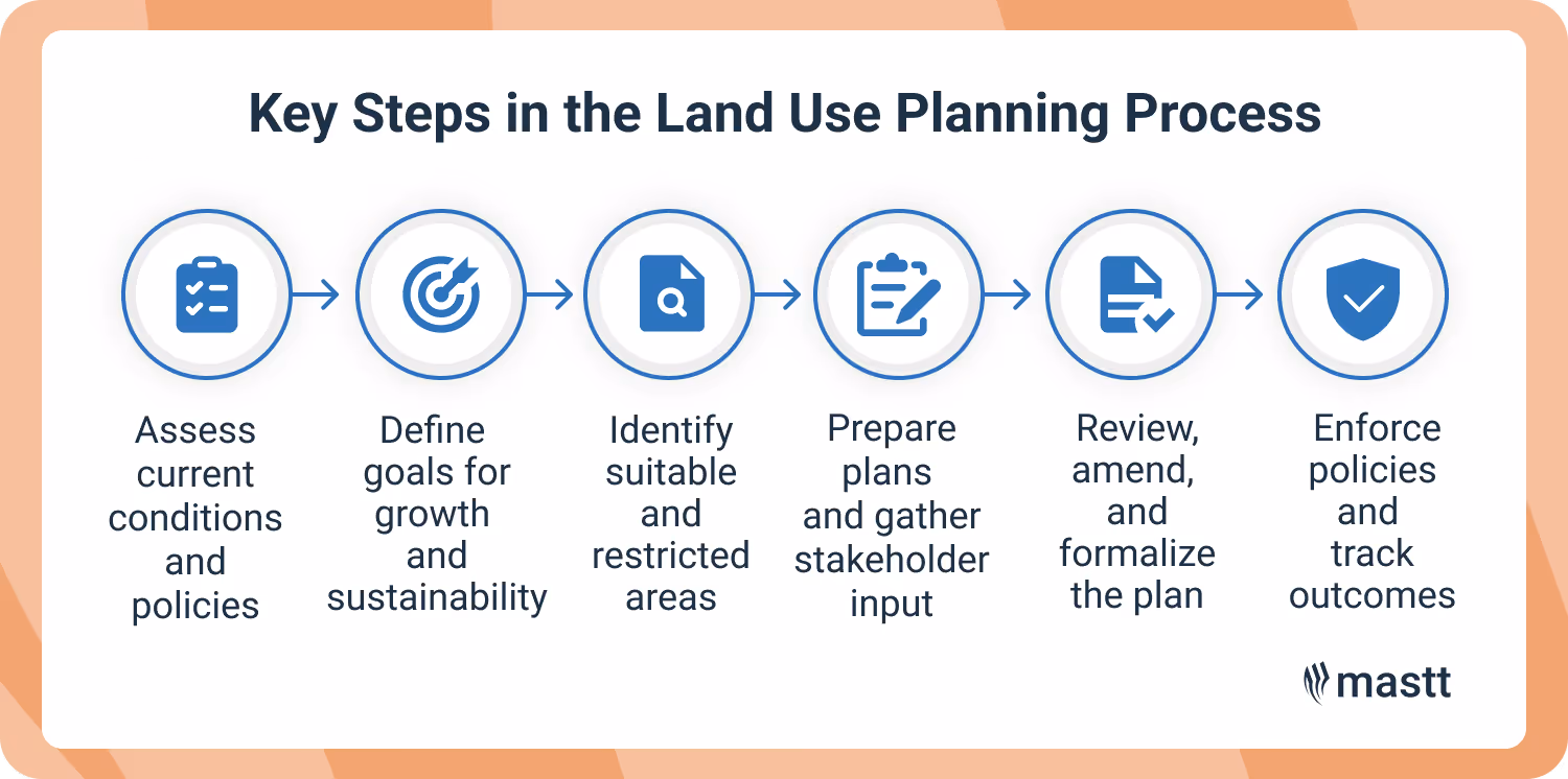
Key Steps in the Land Use Planning Process
The process of planning land use follows a collaborative process that moves from big-picture thinking to detailed, on-the-ground decisions. The steps below outline how land use planning typically unfolds.
Structured planning stages guide smarter, more consistent land development.
Step 1: Establishing the Policy Framework and Gathering Planning Data
Every effective plan begins with understanding existing conditions. Planners assess land characteristics, infrastructure capacity, and current policies to identify constraints and opportunities before shaping future growth.
Review national, regional, and local development policies.
Analyze zoning maps, infrastructure networks, and demographic data.
Use Geographic Information Systems (GIS) and remote sensing to visualize land capability.
Identify heritage areas, environmental risks, and natural resources.
Evaluate housing demand, transport access, and employment trends.
Compare land supply with projected development needs.
This foundation keeps both government and private projects grounded in facts. A solid evidence base streamlines later approvals and funding decisions.
💡Pro Tip: Establish consistent naming conventions, folder structures, and data storage methods. Poor data organization can lead to inefficiency and errors later in the planning process.
Step 2: Defining the Vision and Setting Planning Objectives
Once the groundwork is done, land use planners and stakeholders define what the future should look like. The vision captures how an area will evolve while setting measurable objectives that guide policy and design decisions.
Collaborate with local governments, communities, and developers.
Set goals for housing, sustainability, mobility, and economic growth.
Align the vision with regional strategies and funding priorities.
Identify outcomes that reflect both public benefit and private feasibility.
A shared vision gives every stakeholder a compass that is essential when projects, budgets, or political leadership shift.
Step 3: Assessing Land Suitability and Environmental Constraints
After defining the goals, attention turns to where growth can safely and efficiently occur. Land capability and environmental sensitivity drive these decisions.
Evaluate soil quality, slope, drainage, and flood risks.
Map transport access, utilities, and service connections.
Test land use scenarios against sustainability and infrastructure capacity.
Balance conservation with development opportunity.
This step ensures that land use decisions respect both ecological systems and long-term economic value. It’s where good planning prevents costly redesigns or legal disputes later on.
Step 4: Drafting Land Use Plans and Engaging Stakeholders
This is where ideas turn into maps and policy text. Drafting brings together zoning categories, land use allocations, and design principles that shape how an area will grow.
Translate data and goals into spatial layouts and zoning schemes.
Conduct workshops and consultations with agencies and communities.
Test proposed plans for practicality, cost, and compliance.
Document revisions for transparency and accountability.
Coordinate with housing, transport, and environmental teams for alignment.
Open engagement creates plans people understand and support. Feedback from local residents often reveals details no model can predict.
💡 Pro Tip: Prepare a library of map templates with standardized layouts, legends, and metadata fields for different report types. This ensures consistency and faster output during stakeholder engagement or plan presentation.
Step 5: Securing Plan Approval and Formal Adoption
Once refined, the draft plan goes through formal evaluation. Local governments, planning commissions, or higher authorities review it for compliance with land use regulations and policy frameworks.
Submit the final draft for statutory review.
Conduct hearings or consultations required by law.
Address amendments or conditions recommended by authorities.
Obtain council or agency approval and publish the adopted plan.
Legal adoption gives a plan its authority. For project managers and developers, this step marks the transition from planning concept to actionable policy.
Step 6: Implementing, Monitoring, and Reviewing Land Use Plans
With approval granted, attention turns to delivery. Implementation ensures that zoning ordinances, development controls, and infrastructure investments follow the plan’s intent.
Apply land use and zoning regulations consistently.
Monitor development approvals and infrastructure delivery.
Gather new spatial and environmental data for evaluation.
Report performance indicators to governments and communities.
Revise policies or plans based on results and changing conditions.
Use digital platforms to track progress and share insights.
Good planning adapts to every project built. The best plans evolve like living systems, adjusting to new realities without losing sight of long-term goals.
Smart planning continues through every construction stage and policy update. When each step is followed with evidence, collaboration, and transparency, land use planning becomes the foundation for sustainable, well-managed development.
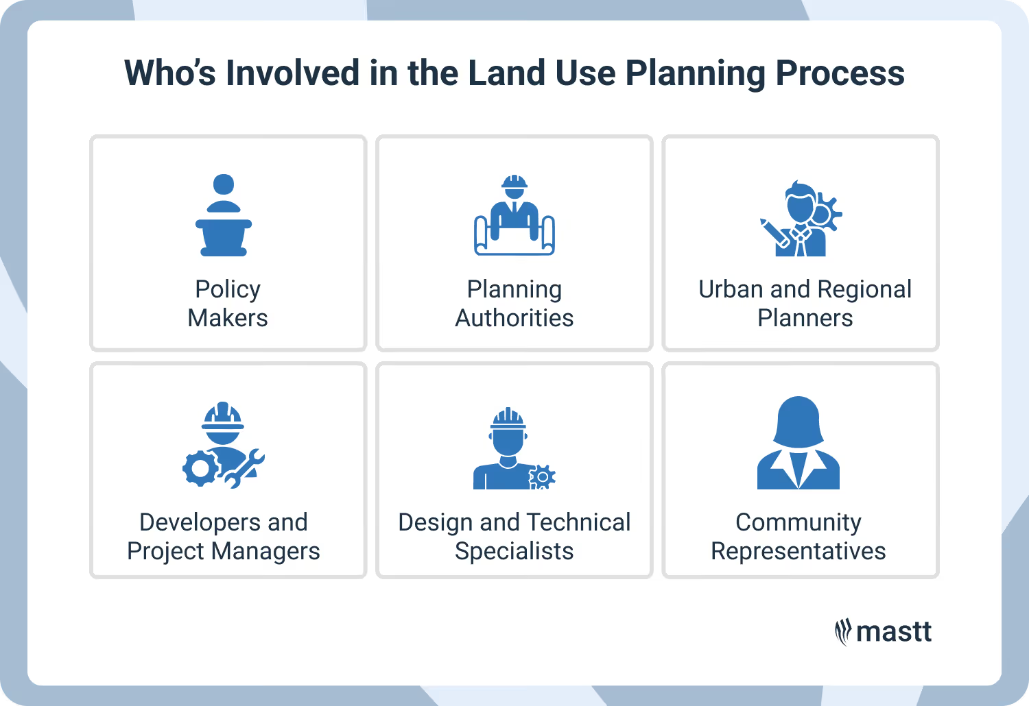
Who’s Involved in the Land Use Policy and Planning Process
Land use policy and planning bring together professionals and institutions with distinct responsibilities at every stage of the process. Each role contributes to shaping how land is used, managed, and developed to achieve sustainable, coordinated growth.
Here are the main roles in the land use planning process:
Policy Makers: Develop the legislative and policy framework that guides how land is allocated and used. They set national and regional priorities for housing, infrastructure, and environmental protection.
Planning Authorities: Oversee the preparation, approval, and enforcement of land use and zoning plans. They ensure development aligns with adopted policies, community needs, and legal standards.
Urban and Regional Planners: Conduct spatial analysis, draft land use plans, and coordinate with stakeholders to balance development, infrastructure, and conservation objectives.
Developers and Project Managers: Implement approved plans through projects that deliver housing, commercial, and public infrastructure. They work within regulatory frameworks to ensure feasibility and compliance.
Design and Technical Specialists: Include architects, engineers, and environmental consultants who translate land use plans into sustainable, functional designs supported by technical data and environmental assessments.
Community Representatives: Provide local knowledge and feedback through consultations and public participation. Their involvement helps align planning outcomes with social, cultural, and environmental priorities.
When these roles work in sync, they create a continuous feedback loop that improves how plans are designed, reviewed, and implemented. Collaboration across policy, design, and data disciplines also helps anticipate future challenges before they affect land use decisions.
Effective land planning depends on coordination between policymakers, planners, and communities.
What Tools are Used in Land Development Planning?
Technology and data now play a central role in how planners design and manage land use. A range of digital, analytical, and regulatory tools supports better decisions by revealing spatial patterns, testing development options, and ensuring growth aligns with long-term community goals.
Here are some of the most widely used tools in spatial planning today:
Geographic Information Systems (GIS): Used to collect, map, and analyze spatial data such as zoning, topography, and infrastructure networks. GIS helps planners understand spatial relationships between land use, population, and environmental factors.
Remote Sensing and Aerial Imagery: Provides accurate, real-time data on land cover, vegetation, and environmental change. These insights guide decisions about conservation, urban expansion, and risk management.
Zoning Maps and Regulatory Frameworks: Define how land can be used, including permitted densities, building types, and environmental protections. They ensure that development remains consistent with spatial planning objectives.
Environmental Impact Assessments (EIA): Evaluate potential environmental and social impacts before development begins. EIAs help align spatial planning decisions with sustainability and compliance standards.
Urban Modeling and Simulation Tools: Allow planners to test alternative development scenarios, forecast infrastructure needs, and assess the impact of growth patterns on transport, housing, and services.
Project Management and Monitoring Platforms: Support coordination between agencies and developers by tracking progress, costs, and performance metrics. AI construction project management software like Mastt enhance accountability and real-time collaboration across teams.
Public Participation Platforms: Enable citizens and stakeholders to view proposals, share feedback, and access open planning data. These tools promote transparency and build trust in spatial planning processes.
Digital innovation continues to expand what planning teams can achieve. With advances in AI, data integration, and real-time modeling, spatial planning tools are becoming more predictive, connected, and responsive.
What are the Different Types and Levels of Land Use Plans?
Land use plans operate across different scales and serve distinct purposes. Some define broad strategies, while others regulate what happens on a single site. Understanding both the levels and types of plans helps connect policy vision with practical development control.
4 Types of Land Use Plans
The type of plan reflects its purpose and what it is designed to achieve. Some plans guide long-term strategy, while others set detailed rules or focus on specific themes such as transport or housing.
Type of Plan
Main Purpose and Focus
Typical Examples or Applications
1. Strategic or Comprehensive Land Use Plan (CLUP)
Sets long-term direction for growth, infrastructure, housing, and environmental protection. Helps align investment with sustainability goals.
National development frameworks, metropolitan strategies, regional spatial plans.
2. Regulatory or Zoning Plan
Defines permitted land uses, building heights, densities, and development controls. Ensures new projects comply with policy and local regulations.
Zoning maps, zoning ordinances, local planning schemes.
3. Sectoral or Thematic Plan
Focuses on one issue or system that affects multiple areas, such as housing, transport, or environmental protection.
Housing action plans, transport corridor strategies, climate adaptation plans.
4. Development Control or Master Plan
Guides the layout and design of specific projects or precincts. Integrates infrastructure, land subdivision, and open space requirements.
Master plans for urban renewal areas, industrial estates, or mixed-use precincts.
These plan types often overlap across levels. For instance, a national strategic plan may guide regional zoning, while a local master plan applies those rules to a single project. Together, they form an integrated planning framework that keeps policy goals aligned from the highest level down to individual developments.
4 Levels of Land Use Plans
The level of a plan refers to the scale or jurisdiction it covers, from national frameworks to site-specific detail. Each level adds a layer of coordination so that decisions made at one scale complement those above and below it.
Level of Plan
Purpose and Scope
Authority or Responsibility
National Plans
Set the country’s overall direction for growth, infrastructure, and sustainable development.
National governments or planning ministries.
Regional or Metropolitan Plans
Coordinate multiple local governments sharing transport systems, ecosystems, and labor markets.
Regional planning agencies or metropolitan authorities.
Local Plans
Regulate zoning, land use, and development within cities or municipalities.
Local councils, city planners, or municipal governments.
Site or Precinct Plans
Define layouts, access, and land use for specific projects or redevelopment areas.
Developers, design teams, and local planning authorities.
Each level narrows from policy to action, translating high-level objectives into spatial rules that shape everyday environments.
Planning Challenges in Land Use Management and Best Practices
Issues in land use plans, such as rapid urban growth, limited data, and conflicting interests, can disrupt implementation. Successful planning requires both foresight and practical solutions that adapt to changing conditions.
The table below highlights frequent challenges in land use planning and offers actionable ways to address them.
Common Challenge
Impact on Planning
Actionable Solution
Urban sprawl and unplanned growth
Leads to inefficient land use, rising infrastructure costs, and loss of agricultural land.
Promote compact development, update zoning regulations, and encourage infill projects near existing infrastructure.
Limited or outdated data
Reduces accuracy in forecasting and decision-making.
Invest in GIS systems, remote sensing, and open data platforms for real-time land use information.
Conflicting stakeholder interests
Delays approvals and weakens community trust.
Use transparent engagement processes, mediation tools, and participatory planning workshops.
Weak coordination between agencies
Creates overlapping responsibilities and policy gaps.
Establish inter-agency committees, shared databases, and unified planning frameworks.
Climate and environmental risks
Increases exposure to floods, heat, and resource depletion.
Integrate climate resilience and environmental protection policies into all levels of land use planning.
Limited implementation capacity
Plans stay on paper without translating into real projects.
Provide technical training, allocate funding, and align planning with budget cycles.
Pressure from rapid population growth
Strains housing, transport, and public services.
Combine long-term growth forecasting with flexible zoning and mixed-use development strategies.
Challenges in land use planning are not one-time problems. They evolve as cities grow and priorities shift. Regular reviews, open feedback, and transparent performance tracking help planners refine plans as conditions change.
Future Trends in Land Use Planning
Land use planning is entering a new phase driven by technology, sustainability goals, and shifting community expectations. Planners are rethinking how data, collaboration, and digital systems can make growth smarter, faster, and more resilient.
These trends highlight where the field is heading and what professionals are watching closely:
Digital Transformation of Planning: GIS platforms, digital twins, and AI tools are changing how plans are created, tested, and approved. Planners can now visualize future development impacts and coordinate projects in real time.
Data-Driven and Collaborative Systems: Open data, shared mapping tools, and cloud-based platforms help governments, consultants, and developers make decisions from the same information source. This transparency builds trust and speeds up approvals.
Climate-Responsive and Resilient Design: Climate adaptation is no longer optional. Cities are integrating flood management, green infrastructure, and energy-efficient layouts directly into land use strategies.
Integrated Land and Infrastructure Planning: Land use decisions are increasingly coordinated with transport, utilities, and public assets. This integration ensures every project supports long-term service delivery and sustainable investment.
Nature-Based and Low-Carbon Solutions: Planners are turning to green corridors, restored waterways, and sustainable drainage systems to improve urban livability and environmental performance.
Scenario Modeling for Future Growth: Digital models allow planners to test “what if” scenarios, exploring how different growth patterns, zoning changes, or transport investments will perform before construction begins.
As technology reshapes planning, new skills are becoming essential. Planners will need to blend spatial analysis, digital literacy, and project management expertise to stay relevant in increasingly data-driven environments.
Strategic Land Planning Shapes the Future of Development
The real value of understanding land use planning lies in applying it to future decisions. Every project, policy, or design choice benefits from early alignment between purpose, place, and people.
Turning insights into action means planning with evidence, collaborating across disciplines, and thinking long-term. When planning moves beyond compliance and becomes a tool for coordination, it shapes outcomes that last.
FAQs About Land Use Planning
Responsibility for land use planning varies by country, but it is generally shared among different levels of government. National authorities set overarching policies and frameworks, while regional and local governments prepare and implement detailed plans. In many places, planners, developers, and communities also contribute through consultation and collaboration.
Geographic Information Systems (GIS) help planners collect, analyze, and visualize spatial data to make informed decisions. They show how land, infrastructure, and environmental features interact, allowing planners to test development scenarios and identify the most suitable areas for growth.
Land use plans are enforced through zoning ordinances, building permits, and development regulations managed by local authorities. Compliance is monitored during the planning approval and construction phases to ensure projects align with approved land uses and policies.
Land use planning sets the overall strategy for how land should be used and developed across an area. Zoning is one of the tools used to implement that strategy, defining specific rules for land use, density, and building standards in different zones.
Land use planning identifies which areas are suitable for specific types of development, helping determine where projects can be approved. By clarifying restrictions, access, and infrastructure availability early, it reduces risk and improves the accuracy of feasibility assessments.
Written by
Kristel Sapungan
Kristel Sapungan is a licensed architect and Content Writer at Mastt, combining her technical background with expertise in SEO and digital strategy. With experience in architectural design, construction documentation, and on-site coordination, she delivers precise, high-quality content for the construction and capital works sector. Her work enhances industry communication by translating complex concepts into clear, professional narratives.